CADMAP Limited is a leading surveying and geomatics company in the United Kingdom, established in 2011 by our founder, Michael Brett. We provide specialist services including topographical land surveys, measured building surveys, PAS 128 utility mapping, CCTV drainage surveys, laser scanning and BIM modelling. Our work delivers precise and dependable survey data for architects, engineers, developers, infrastructure organisations and governmental bodies. We operate across London, the South East and throughout the United Kingdom, supporting projects of varying scale and complexity.
Under Michael Bretts leadership, we have developed from a small surveying practice into an award-winning organisation with a multidisciplinary workforce of surveyors, CAD technicians and utility mapping specialists. Michael began his career in surveying in 1999, gaining extensive experience in land surveying, geomatics, CAD management and digital marketing prior to founding CADMAP. His approach combined technical precision with innovative online marketing strategies, establishing CADMAP as one of the most recognised surveying brands in Britain.
Under Michael Bretts leadership, we have developed from a small surveying practice into an award-winning organisation with a multidisciplinary workforce of surveyors, CAD technicians and utility mapping specialists. Michael began his career in surveying in 1999, gaining extensive experience in land surveying, geomatics, CAD management and digital marketing prior to founding CADMAP. His approach combined technical precision with innovative online marketing strategies, establishing CADMAP as one of the most recognised surveying brands in Britain.
Served areas
- The whole UK - London, Surrey, Sussex, South East
Details
- Year established: 2011
- Employees: 25
- Licensed
- Insured
Highlights and features
- Topographical Surveys
- GPR Surveys
- Measured Building Surveys
- BIM Scanning
- Rebar Scanning
- Concrete Scanning for depth and Rebar
- 3D Scanning
- Revit Models
- Drainage Surveys
- CCTV Drainage Surveys and Jetting
Associations and certifications
- Full Member the TSA - The Survey Association
- CICES
Payment methods
- Bank transfers
Services
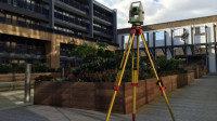 We assist developers, architects, designers, and homeowners with professional land topographical surveys tailored to project requirements. Our surveys provide precise measurements and mapping of land levels, ensuring dependable information for design and development work. Every survey is completed using Leica total stations by qualified land surveyors with extensive technical expertise. Our team is fully certified for work on building sites and within educational environments.
 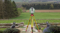 Our team provides measured building surveys that combine accuracy with comprehensive documentation. We utilise modern surveying methods to produce coordinated floor plans, elevations, sections, and topographical surveys. These services are frequently used by architects and developers for planning applications. We ensure all data is processed into CAD formats including DWG, DXF, and PDF. Our surveys are carried out in line with RICS requirements.
 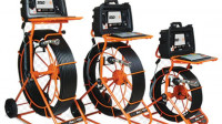 We provide CCTV drainage surveys across London, Surrey, Berkshire and Sussex using advanced camera technology. Our specialist surveyors inspect underground pipework to assess condition and trace systems accurately. Surveys are conducted with MiniCam Solo Pro 100 metre equipment and Wincan V8 reporting software. Findings are delivered with precise observations of pipe structure, flow and construction type.
 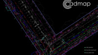 Cadmap Limited produces PAS128 GPRS surveys for clients from homeowners to blue chip organisations. A GPR survey is a non-invasive method for detecting and mapping underground features such as pipes, cables and voids including. It emits radar pulses into the ground which reflect when different electrical properties are encountered. The resulting data is processed into images or 3D maps used in construction, utilities and archaeology.
  We provide boundary survey services through Cadmap Ltd to clients requiring accurate land assessment. Such surveys demand experienced surveyors and specialist equipment, as conventional measuring tools cannot achieve the necessary precision. We assist with resolving disputes, preparing land registry compliant plans, and calculating site areas. Our outputs include detailed boundary documentation and supporting plans for record keeping.
 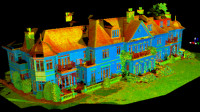 Cadmap deliver a comprehensive range of 3D laser scanning services using advanced technology. The Leica ScanStation P20 is capable of capturing up to one million points per second, enabling rapid acquisition of high-definition survey data. It is ideal for short timeframes or very dense capture requirements. We support elevations, floor plans and specialist surveying projects.
 Videos

Cadmap Ltd - Land and Building Surveying
1. Topographical Land Surveys
Topographical Land Survey | CADMAP Ltd | London & South East
Discover how CADMAP Limited delivers accurate, detailed topographical surveys for construction, planning, and design. Using total stations, GNSS & drones, we capture all above-ground and site-specific features for architects, engineers, and developers.
Full AutoCAD or Revit Output
Spot Levels, Contours, Boundaries, Features
Ideal for Planning Applications & Site Design
Fast Turnaround | TSA & RICS Accredited