Business Details
Your Trusted Chartered Surveyors in Stroud
Geomap has been delivering professional surveying services for over 15 years, combining traditional expertise with cutting-edge technology to meet client needs. Our team of chartered surveyors specialises in topographic, building, and utility surveys, utilising advanced tools like laser scanning and photogrammetry to ensure precision. We maintain ISO 9001 certification, reflecting our commitment to quality standards and continuous improvement.Our approach prioritises tailored solutions, enabling cost-effective, efficient project delivery while adhering to strict quality assurance protocols. With extensive experience across diverse projects, we work closely with clients to achieve budgetary and quality objectives, supported by ongoing staff training and technical innovation.
Services
Topographic Surveys
Building Surveys
Utility Surveys
Laser Scanning
3D Modelling
Highlights and features
- We have over 15 years' experience in professional surveying services
- Our ISO 9001 certification demonstrates our commitment to quality standards
- We combine traditional methods with advanced laser scanning technology
- Our tailored approach ensures cost-effective, accurate project delivery
- We maintain ongoing staff training and technical innovation programs
Associations and certifications
- ISO 9001
What people say
Accurate and detailed
Innovative solutions
Reduced site visits
Quickly and professionally
Quality work within budget
Services
Topographic Surveys
Our topographic surveys create detailed 2D and 3D maps of land features using advanced photogrammetry and hydrographic techniques. This essential data supports design and planning projects with high accuracy. Clients benefit from reliable information for infrastructure development and environmental management applications.
Building Surveys
We conduct comprehensive building surveys using traditional methods combined with laser scanning technology to capture precise structural details. Our surveys produce accurate plans and models for renovation or development projects. Clients receive detailed documentation that supports architectural design and construction planning processes.
Utility Surveys
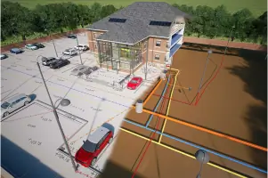
Our utility surveys employ ground-penetrating radar and drainage assessment techniques to identify subsurface infrastructure. This critical information helps prevent construction conflicts and supports utility management. Clients receive detailed mapping of underground services with accurate positional data for safe project execution.
Laser Scanning
We utilise laser scanning technology to create high-resolution digital models of buildings and structures. This non-invasive technique captures millions of data points for precise documentation. Clients benefit from reduced site visits and enhanced data accuracy for complex surveying requirements.
3D Modelling
Our 3D modelling services transform survey data into detailed digital representations for planning and visualisation purposes. Using photogrammetry and scan data, we create accurate models for design development. Clients gain valuable insights through immersive digital environments that support decision-making processes.
Questions
What surveying services does Geomap offer?
We provide topographic, building, and utility surveys using advanced technology combined with traditional methods for precise data collection.
How does Geomap ensure quality standards?
We maintain ISO 9001 certification with documented quality assurance procedures and continuous staff training to guarantee consistent service excellence.
What technology does Geomap use?
We utilise laser scanning, photogrammetry, and ground-penetrating radar alongside traditional surveying equipment for comprehensive data capture.
How does Geomap work with clients?
We collaborate closely with clients to understand project requirements and deliver tailored solutions that meet budget and quality objectives.
Which areas does Geomap cover?
While based in Stroud, we provide surveying services across Gloucestershire and surrounding regions for diverse infrastructure projects.