SJ Geomatics Ltd provides UK-wide land, engineering and specialist surveying services for residential, commercial and infrastructure projects. We support clients from feasibility and design through construction and handover, delivering accurate, construction-ready data with clear outputs, responsive communication and dependable turnaround.
Our services include topographical surveys and measured building surveys (plans, elevations and sections), utility & GPR surveys, CCTV surveys, and setting out & engineering support (control, checks and as-built verification). We also deliver advanced capture and modelling solutions including 3D laser scanning with BIM-ready models, plus drone surveys & aerial mapping for efficient coverage and hard-to-access sites. Specialist capability includes rebar scanning, bathymetric sonar surveys, and thermographic surveys. We can also produce Land Registrycompliant plans and provide AutoCAD services for survey drafting, drawing updates and as-built documentation.
Were a prequalified, accredited and professionally aligned supplier, including Builders Profile, Achilles, Constructionline (Gold Member), SMAS Worksafe/SSIP, Once For All, Citation Approved (Health & Safety), JOSCAR, Social Value, Chartered ICES, FSB, ARPAS-UK, and ICO registration. We are ISO27001:2022, ISO 9001:2015 and ISO 14001:2015 accredited, with ISO 22301 and ISO 45001 currently in progress.
Whether you need a one-off survey or ongoing site support across multiple locations, SJ Geomatics delivers reliable results you can build on.
Served areas
- Nationwide
Details
- Year established: 2012
- Employees: 6
- Licensed
- Insured
Highlights and features
- Nationwide land and building surveys delivered with precision
- Professional friendly service with proven surveying expertise nationwide
- State-of-the-art equipment ensuring accurate high-quality survey results consistently
- Comprehensive surveying solutions from planning through construction stages
- Experienced surveyors trusted by public and private sector clients
- Cost-effective time-sensitive services tailored to project requirements nationwide
Associations and certifications
- Chartered ICES
- ISO9001
- ISO14001
- ISO27001
- ISO45001
- ISO22301
- Constructionline Gold
- Achilles
- Accredit
- Joscar
- SMAS - SSIP
- Arpas UK - The Drone Association
- Suffolk Chamber of Commerce
- Federation of Small Businesses
Payment methods
- Checks, Debit cards, Credit cards, Bank transfers
Services
SJ Geomatics Ltd provides UK-wide land, engineering and specialist surveying services for residential, commercial and infrastructure projects. We support clients from feasibility and design through construction and handover, delivering accurate, construction-ready data with clear outputs, responsive communication and dependable turnaround.
Our Topographical Surveys provide an accurate, up-to-date record of site conditions for planning applications, design development and construction coordination. We measure both plan features and levels, capturing items such as buildings, boundary treatments, surface materials, kerb lines, road/footpath details, drainage features, manholes and covers, overhead/visible services, vegetation, water features and general ground modelling through spot levels and breaklines.
Surveys are undertaken using the most appropriate method for the projectGNSS, total station and/or 3D laser scanningensuring accuracy, efficiency and suitability for the site environment. Deliverables can be issued in AutoCAD, PDF and GIS formats, including DTM/surface models, contours, spot levels, and annotated plans, aligned to your required coordinate system and specification.
Surveys are undertaken using the most appropriate method for the projectGNSS, total station and/or 3D laser scanningensuring accuracy, efficiency and suitability for the site environment. Deliverables can be issued in AutoCAD, PDF and GIS formats, including DTM/surface models, contours, spot levels, and annotated plans, aligned to your required coordinate system and specification.
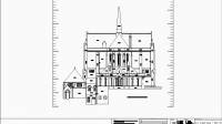 Our Measured Building Surveys provide an accurate record of existing buildings, capturing internal layouts and external features to support refurbishment, extension design, space planning, compliance works and asset management. We measure key elements such as wall positions, openings, structural features, levels, ceiling heights and building extents, using the most appropriate method for the sitetotal station, GNSS where suitable, and/or 3D laser scanning for complex environments.
Deliverables are issued to your required specification and can include floor plans, elevations, sections, reflected ceiling plans, height/level information, and CAD/PDF outputs. Where required, we can also supply BIM-ready models derived from scan data to support coordination and clash avoidance.
3D laser scanning is a high-definition survey method that captures very high-density spatial data in a fraction of the time required by traditional techniques.
A terrestrial laser scanner emits a laser beam in both the horizontal and vertical planes, rotating through 360 to record millions of measurements. Reflected signals are detected and processed at very high ratesoften up to 100,000 points per secondproducing a detailed, accurate representation of the environment.
In addition to the standard geometric survey information, the resulting point cloud also records attributes such as range (distance) and return intensity, providing rich datasets suitable for precise modelling, verification, and BIM-ready outputs.
Our Underground Detection / Utility Survey service helps clients understand whats below ground before design, excavation or intrusive works begin. Using a combination of electromagnetic locating (EML) and Ground Penetrating Radar (GPR), we detect and trace buried utilities such as electricity, telecommunications, gas, water and drainage (where conditions allow).
We correlate findings with available records, undertake site reconnaissance, and present results as clear, usable deliverablestypically annotated utility plans, CAD/GIS outputs and marked-up site information. Where appropriate and achievable, we can provide depth estimations and feature attributes, with results reported transparently so limitations and confidence levels are understood. This supports safer working, better coordination and reduced likelihood of service strikes, delays and rework.
We correlate findings with available records, undertake site reconnaissance, and present results as clear, usable deliverablestypically annotated utility plans, CAD/GIS outputs and marked-up site information. Where appropriate and achievable, we can provide depth estimations and feature attributes, with results reported transparently so limitations and confidence levels are understood. This supports safer working, better coordination and reduced likelihood of service strikes, delays and rework.
Our GPS (GNSS) Land Survey service uses survey-grade receivers to capture accurate spatial data by measuring positions from multiple satellite constellations. This enables fast, reliable collection of coordinates across sitesparticularly effective for large areas and open environments. We can map existing features, establish site control, support boundaries and deliver design-ready information for planning and construction. Outputs are provided in the required format (CAD, PDF, GIS and/or coordinate lists), referenced to the appropriate coordinate system and control, with clear documentation of survey scope and assumptions.
SJ Geomatics delivers Drone Surveys & Aerial Mapping across the UK, providing fast, safe capture of high-quality site data for planning, design, construction and asset management. UAV surveys are ideal for large areas, live sites and locations that are difficult or unsafe to access on foot, while still producing highly usable mapping and model outputs.
Depending on the project requirements, deliverables can include georeferenced orthomosaic imagery, digital surface models (DSM), digital terrain models (DTM) (where achievable), contours, 3D mesh models, and measurement-ready mapping for areas, distances and volumes. Drone data can be integrated with ground control and traditional survey methods where required, and supplied in CAD/GIS-friendly formats to suit your workflow.
Depending on the project requirements, deliverables can include georeferenced orthomosaic imagery, digital surface models (DSM), digital terrain models (DTM) (where achievable), contours, 3D mesh models, and measurement-ready mapping for areas, distances and volumes. Drone data can be integrated with ground control and traditional survey methods where required, and supplied in CAD/GIS-friendly formats to suit your workflow.
SJ Geomatics provides experienced Setting Out Engineers to support construction and civil engineering works across the UK. We establish and maintain site control, set out works to design coordinates and levels, and provide ongoing verification to ensure construction is delivered accurately and efficiently.
Typical tasks include setting out for foundations, piling, groundworks, drainage runs and manholes, kerbs and highways geometry, slabs, steel frame/gridlines, retaining walls, columns and structural elements, as well as hold-point checks, dimensional verification and as-built surveys for handover documentation. We work closely with site teams, designers and subcontractors, communicating clearly and resolving issues early to reduce rework and programme risk.
Deliverables can include as-built drawings, coordinate schedules, survey reports and CAD updates, issued in the formats your team needs.
Our Rebar Surveys use specialist scanning equipment to detect and map reinforcement within concrete elements such as slabs, beams, columns, walls and decks. This service supports both risk reductionby identifying safe drilling/coring zonesand quality assurance, by verifying reinforcement layout, spacing and cover where required.
Rebar scanning is commonly used prior to diamond drilling, coring, saw cutting, anchor/fixing installation, and during investigations or refurbishments where drawings are incomplete or uncertain. Results are provided as clear marked-up plans or annotated outputs showing reinforcement locations and recommended working zones, with findings explained in a straightforward report to support safe and efficient site operations.
Rebar scanning is commonly used prior to diamond drilling, coring, saw cutting, anchor/fixing installation, and during investigations or refurbishments where drawings are incomplete or uncertain. Results are provided as clear marked-up plans or annotated outputs showing reinforcement locations and recommended working zones, with findings explained in a straightforward report to support safe and efficient site operations.
 Our CCTV Surveys provide a detailed visual inspection of underground drainage and pipework to assess condition, confirm connectivity and identify issues before they become costly problems. Using specialist camera systems, we survey pipelines to locate defects such as cracks, deformation, root ingress, displaced joints, silt build-up, blockages and structural damage.
CCTV surveys are commonly used for pre-purchase investigations, asset condition assessments, new drainage verification, adoption support, and pre- and post-construction checks. Deliverables typically include video footage, inspection logs, and a clear condition report summarising observations and highlighting priority defects. Where required, we can integrate findings with survey drawings/CAD outputs to support design coordination and remedial planning.
Whether your project is planning, development, feasibility or design, it will benefit from an accurate and current topographical survey.
Our highly skilled team of surveyors has worked on a wide variety of projects including single house plots, large housing developments, domestic gardens, Highways, Schools and high profile projects.
We are currently engineers on the largest mushroom farm in Europe, being constructed in East Anglia.
Our reliable and highly experienced team of surveyors can help you determine the specification you need should you require advice.
SJ Geomatics CAD Bureau supports clients with reliable AutoCAD drafting and drawing production, helping teams keep documentation accurate and up to date. We can create new drawings or work within your existing CAD standards, layering, title blocks and templates to ensure seamless integration with your workflow.
Typical services include topographic and measured building drawing production, as-built plans, setting-out and coordinate schedules, Land Registrycompliant plan drafting, redline updates, drawing clean-up and standardisation, and data conversions between common formats. Where required, we can also produce CAD outputs derived from 3D laser scanning/point clouds and drone mapping, providing design-ready drawings and models from high-density survey data.
Deliverables can be issued in DWG/DXF and PDF, with clear version control and consistent presentation to suit planning, construction and handover requirements.
SJ Geomatics provides structured point cloud delivery from terrestrial laser scanning and aerial capture, supplying high-density spatial datasets suitable for design coordination, verification, and BIM workflows. We process and register scan data, align it to the agreed coordinate system/control, and issue deliverables in formats that integrate smoothly with your software and standards.
Deliverables can include registered and georeferenced point clouds, optional colourisation, scanworlds/stations, and clipped/segmented datasets for easier handling. We can supply data for use in common platforms (e.g., CAD/BIM coordination and review environments) and provide supporting outputs such as snapshot views, orthographic elevations, sections, level information or extraction-ready datasets where required. File formats can be provided to suit the project, including commonly used point cloud formats (e.g., E57 / LAS / LAZ / RCP / RCS / PTS), with clear naming, version control and transfer option
Deliverables can include registered and georeferenced point clouds, optional colourisation, scanworlds/stations, and clipped/segmented datasets for easier handling. We can supply data for use in common platforms (e.g., CAD/BIM coordination and review environments) and provide supporting outputs such as snapshot views, orthographic elevations, sections, level information or extraction-ready datasets where required. File formats can be provided to suit the project, including commonly used point cloud formats (e.g., E57 / LAS / LAZ / RCP / RCS / PTS), with clear naming, version control and transfer option
People
Steve Jones TCinstCES
Director
Steve Jones is the Director of SJ Geomatics Ltd, a Member of ICES, and has over 30 years experience supporting construction, engineering and property projects with reliable surveying and geomatics services. Steve leads project delivery across the UK, ensuring survey outputs are accurate, clearly presented and aligned with design and site requirements, with a strong emphasis on quality, safety and responsive client support.
Reviews (1)
Andrew
Apr 27, 2025
Report