
Business Details
15 Years
experience
Emergency
services
Chartered Land Surveyors in Ashford, Kent
Established in 2011, R L Surveys is a family-run chartered land surveying practice based in Ashford, Kent. Our team of experienced professionals brings over two decades of industry expertise to deliver precise and tailored surveying solutions across Kent, London, Essex, Sussex, and Surrey. Specialising in topographical surveys, measured building surveys, and boundary resolution, we utilise cutting-edge technology including 3D laser scanning to meet diverse client needs. Our commitment to accuracy and repeatability ensures reliable data collection for projects ranging from short-term assessments to long-term monitoring. We maintain strong industry accreditations, including membership with the Royal Institution of Chartered Surveyors (RICS) and the Chartered Institute of Civil Engineering Surveyors (CICES). Our surveyors have worked on high-profile projects for major developers, contractors, and local authorities, demonstrating our technical proficiency and adaptability in varied environments.We prioritise transparency in pricing, offering fixed-fee structures for monitoring programmes and emergency site visits. Our investment in advanced equipment like the Leica C10 ScanStation enables efficient data capture without compromising precision. By assigning consistent personnel to projects, we minimise error margins and ensure continuity for clients. With direct links to London and nationwide coverage, we provide competitive tenders for surveying requirements across the UK. Our reputation for professionalism and technical excellence has been built through two decades of delivering client-focused solutions that meet exact specifications.
Services
Land/Topographical Surveying
Measured Building Surveys
3D Laser Scanning
Boundary Issues
Structural Monitoring
Details
- Year established: 2011
Highlights and features
- We offer over 20 years of chartered surveying expertise
- Our family-run business guarantees consistent personnel for projects
- We provide competitive tenders for nationwide surveying requirements
- Our fixed-fee structures ensure transparent pricing
- We utilise Leica C10 ScanStation technology for precise 3D data capture
Associations and certifications
- Royal Institution of Chartered Surveyors (RICS)
- Chartered Institute of Civil Engineering Surveyors (CICES)
Services
Land/Topographical Surveying
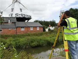
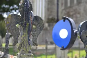
Our land surveying services create detailed 2D and 3D plans for construction and redevelopment projects. Using GPS and total stations, we map terrain features and elevations with millimetre precision. Our surveys support infrastructure planning, site analysis, and volume calculations for clients across the construction industry.
3D Laser Scanning
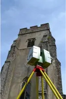
We employ Leica C10 ScanStation technology to capture millions of data points per second, creating accurate 3D point clouds of structures and landscapes. This non-intrusive method provides detailed digital models for architectural analysis, engineering assessments, and heritage preservation projects without compromising traditional survey accuracy.
Boundary Issues
Our boundary resolution service combines GPS technology with Ordnance Survey mapping to clarify property lines and resolve disputes. We produce detailed reports comparing physical boundaries with Land Registry title plans, supporting first registrations, land transfers, and sub-division projects across residential and commercial properties.
Structural Monitoring
We implement precision monitoring systems for short-term assessments and long-term structural analysis. Using repeatable measurement techniques, we track movements in buildings, coastal defences, and infrastructure projects. Our fixed-fee programmes include regular site visits and detailed reporting for clients requiring ongoing stability assessments.
Measured Building Surveys
Our measured building surveys produce accurate floor plans, elevations, and cross-sections for existing structures. Using laser technology and traditional methods, we document internal dimensions and architectural features to support renovation projects, lease plans, and building information modelling (BIM) requirements.
People
Mike Holiday
Chartered Land Surveyor
With over 20 years of post-qualification experience, Mike specialises in topographical, hydrographical, and boundary surveys. He has worked on major UK infrastructure projects for leading developers and contractors, bringing extensive technical expertise and practical problem-solving skills to R L Surveys.
Questions
What surveying services do you offer?
We provide topographical surveys, measured building surveys, 3D laser scanning, boundary resolution, and structural/landform monitoring services for construction and redevelopment projects.
Which areas do you cover?
Our primary service areas include Kent, London, Essex, Sussex, and Surrey, with nationwide coverage available for competitive tenders.
How experienced is your team?
Our surveyors have over 20 years of combined experience working on projects for major developers, contractors, and local authorities across the UK.
Do you offer emergency monitoring services?
Yes, we can attend sites at short notice for emergency monitoring exercises while maintaining our standard fixed-fee pricing structure.
What technology do you use?
We utilise Leica C10 ScanStation technology for 3D laser scanning, achieving 1 million points per second with high accuracy in various weather conditions.
Are you professionally accredited?
Yes, we hold memberships with the Royal Institution of Chartered Surveyors (RICS) and the Chartered Institute of Civil Engineering Surveyors (CICES).